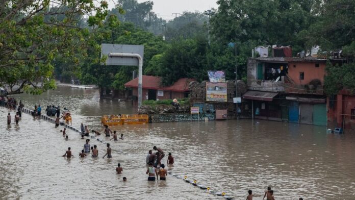
Some eight years ago, I had argued on these pages that flash floods have long been a feature of life on the Indo-Gangetic floodplains. Archival sources on south Bihar dating back to the 1860s, when India was primarily an agricultural economy, showed that sudden floods during the rainy season were the norm, as the Gangetic riverine network overflowed its banks.
These floods, however, receded within days, causing little damage and leaving a layer of fine silt that replenished the soil and enhanced farm productivity. Drought and monsoon failure, rather than floods, were the main worries then.
The origins of waterlogging on the floodplain can be traced to early public developmental works under British rule, such as canals, all-weather roads and railways, that involved construction of embankments that often blocked lines of natural drainage. The problem has been compounded since with large-scale urbanization.
The NCR, located on this floodplain, needs just three hours of heavy rainfall to be flooded, and isolated pools of floodwater can stagnate for days, harming infrastructure, private property and even life. Mumbai, Chennai, Thiruvananthapuram and other Indian cities suffer similarly.
Eight years ago, I was of the view that better drainage could resolve the problem. On further reflection, since, it has dawned on me that it’s so complex that flash floods in NCR cannot be prevented, only mitigated and managed.
If NCR were situated on a coast, excess water could drain into the sea. Delhi, however, is on the inland Indo-Gangetic floodplain that’s one of the flattest places on earth. Normal rainfall water goes into water harvesting structures that recharge the phreatic/surface water table (natural bodies like rivers, ponds, open-raw wells and other artificial structures).
But under incessant and excessive rainfall, this phreatic table gets fully recharged and rises to ground level. This water table differs from the intricate web of deep sub-surface aquifers, from which tube wells draw water and where water has accumulated over millennia. The two tables are linked, but we don’t know exactly how.
Once the phreatic water table is fully charged where can the excess water go, especially since river levels are rising and overflowing their banks?
In coastal cities, the answer is clear, as sea-drainage guards against floods provided an adequate drainage system is in place and in good repair under routine maintenance.
In floodplains, however, drainage to the sea can only occur over an extended period, since rivers have to cover a long distance to reach their outlet. Flash floods take place on account of this time difference. Once heavy rains cease, the waters subside and recede back into the original river bed.
What then are the possible long-term solutions, assuming drainage systems are well designed, adequate and kept in good repair?
First, more upstream reservoirs (including hydroelectric projects) in the hills, from where the rivers flow down to the floodplain. There are associated environmental, technical and flooding concerns that need to be addressed, though, while designing these.
Reservoirs have indeed been increasing over time, but might be inadequate to prevent flooding downstream as monsoon rains cover the entire Indo-Gangetic plain, and much of the flow into rivers at this time is downstream.
Second, desilt, deepen, revive and increase the area under ponds, wells, lakes and other water harvesting structures where excess water can flow during the monsoon season. These water storage devices would also increase water availability during the long dry season that follows the monsoon and during which there is extensive water shortage, both for drinking purposes and agriculture.
Three, minimize the built-up area under concrete, asphalt, etc, in urban areas so as to increase the recharge of sub-surface water. We need more parks, playgrounds, uncovered sidewalks by roadsides, buildings, etc.
Four, the blocked natural lines of drainage need to be de-obstructed while designing and reworking drainage systems so that excess water can flow towards the Yamuna and not accumulate in low-lying areas. Underpasses in particular should be avoided. It is far better to have elevated overpasses.
Five, needless to say, drainage systems need to be well maintained and kept in good repair so that they are not clogged with dirt, waste material, plastic, etc, that obstruct the flow of water.
My broad sense is that while such measures would mitigate the problem during monsoon rains, ultimately there is no preventing the water table from rising in the floodplains during the rainy season, as historical evidence cited in the article indicates, and consequential flash floods.
Large and dense urban agglomerations like the NCR are fundamentally unsuited to such a vast flat floodplain that is so far from the sea. Urban planners and architects need to take seasonal flooding into account.
#Urban #flooding #havoc #Dig #deeper #root
